Success Story 13. Spatial Rice Decision Support System (SRDSS)
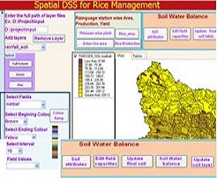
Several DSS systems were developed for agricultural management, but majority of them addressed issues like scheduling irrigation and water requirements. There has been limited research on decision support systems for crop growth and yield estimation, more particularly for rice. Spatial Rice Decision Support System (SRDSS) was designed to link spatial databases (GIS based) with Oryza2000 rice model in order to facilitate the selection of target area, management strategies and various scenarios for rice yield prediction and mapping. The decision support system consists of organized databases holding spatial and temporal data of local conditions and process models for simulating the growth of an irrigated rice crop. This interface was designed using Visual Basic and Map Objects with Microsoft Access as back end. Customized screens were created for entering the input data for the model. There were two main interlinked interfaces. One is interface to model and other one is interface to spatial rice DSS (SRDSS). User prompts for location of model files, crop growing dates, number of rainguage stations, weather data, thiessen layer or rainfall layer and soil layer. Then by using thiessen polygon wise yield button, rice yield was estimated and by clicking the soil water balance button, water balance was estimated for the target location and the target growing period.
SRDSS simulates crop growth, soil water balance over the landscape while the GIS functionality provides spatial visualization of results. This interface is not only used for yield estimation. User can choose best crop growing period as input and they can change different management processes like application of fertilizer, or spacing between plants etc to get maximum yield by giving weather data.
The integrated framework will provide synergy between geospatial and temporal agricultural information that aids decision making for local and regional planners. In addition, the integrated model will assist in the presentation and understanding of soil/water and crop growth variables on a spatial scale.
Practical Utility: As different components are involved in management of rice crop like crop modelling, physiology (weather and crop growth), agronomy(management practices) and spatial technologies i.e. Remote sensing and GIS , a common user or a planner or researcher may not be having knowledge in all these components. Hence a common platform to combine access to all these components without knowledge into individual components is useful for rice management.


